
The team at Forensic Architecture use remote sensing technology and architectural models to map violence against humanity. In our interview with research coordinator Omar Ferwati, we focus on the ongoing analysis of the Amazon rainforest in Brazil.
The Forensic Architecture department at Goldsmiths University in London is a multi-disciplinary research agency that draws upon cutting-edge spatial analysis tools, open-source technology and digital modeling to carry out hard-hitting investigations of human rights issues. In 2022, they released a major report about gold mining and violence against the Yamomami indigenous group in the Brazilian part of the Amazon rainforest during now-former president Jair Bolsonaro’s administration.
We spoke to FA’s research coordinator, Omar Ferwati, who is an architect by trade, about the Amazon project and how his professional background can be applied in the pursuit of truth.
ArchiExpo e-Magazine: “Forensic architecture” is an intriguing term that could carry a lot of diverse interpretations. In the case of your studio, what exactly does it mean?
Omar Ferwati: You can think about forensic architecture as a way of repurposing our skills and understanding of space to investigate crimes against humanity and encroachment on human rights which reveal themselves in the material environment where they happen.
The environment reveals information about how the incident unfolds, which is evidence that would not otherwise be visible. Architecture is the way we read an environment in which events of violence take place. It allows us to recreate and rebuild those environments while situating other pieces of information and evidence.
When we work with fluid dynamics experts and acoustics experts, it is through these architectural models that we can test scenarios, simulations and timelines of events that happened within them. We work in consultation with many disciplines, but the environments that we are recreating and analyzing sit at the base of that collaborative process. Our team is made up of people trained as architects, journalists, lawyers, software engineers, artists and so on.
ArchiExpo e-Magazine: How did those innovative research methods apply to your Amazon project in particular?
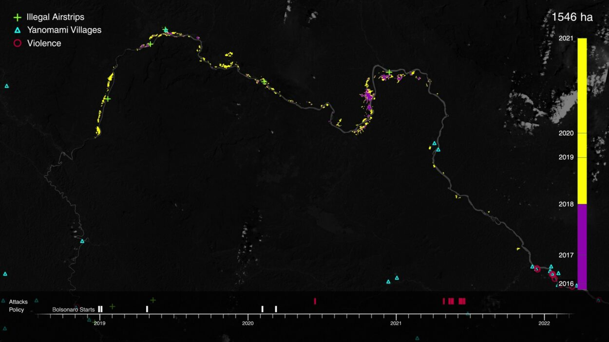
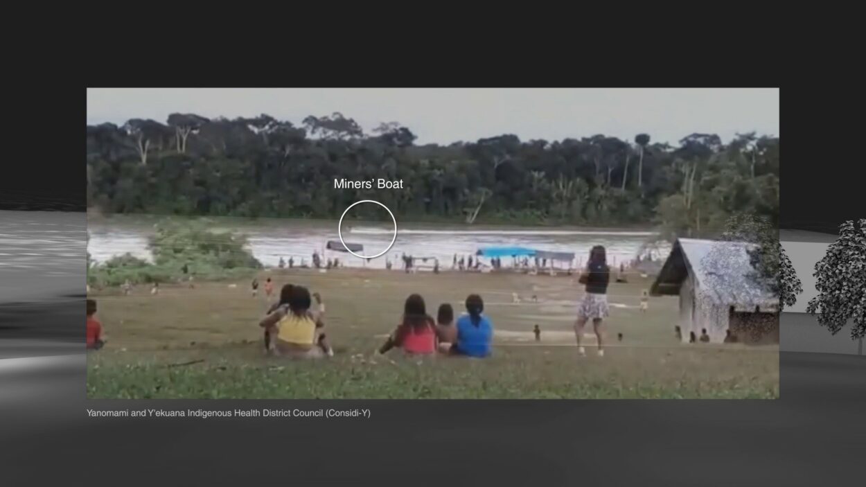
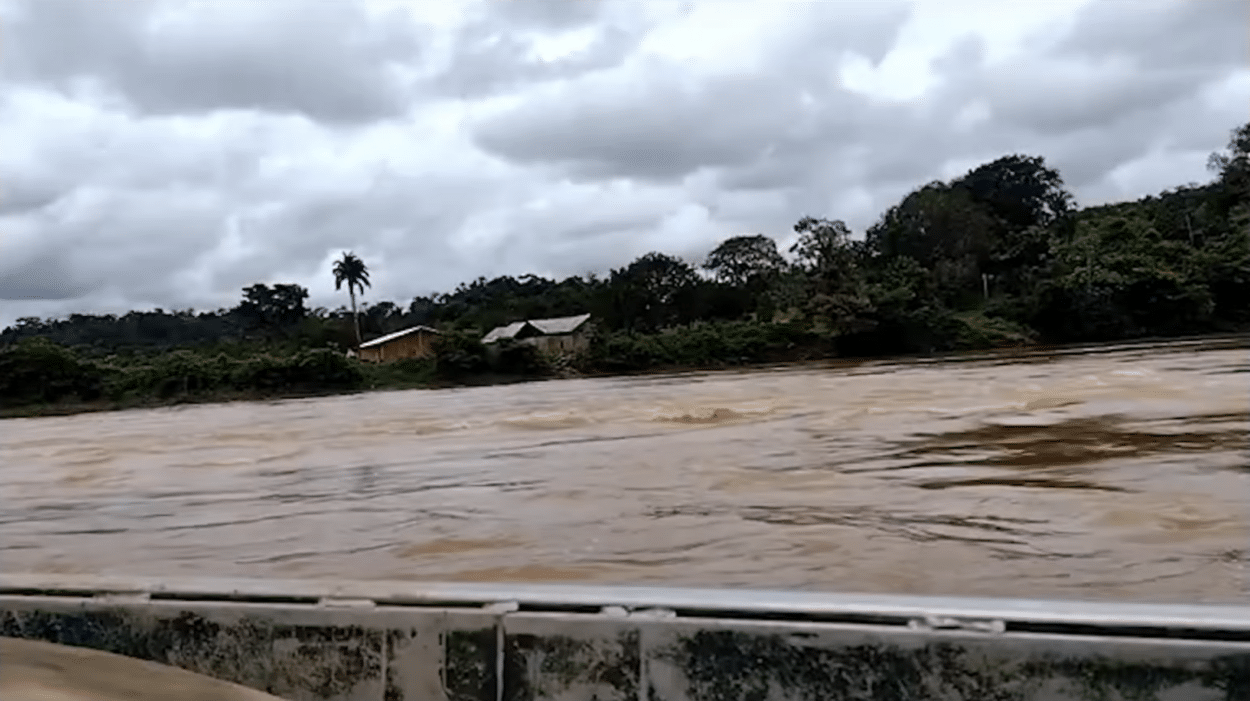
Omar Ferwati: We began by looking at different evidence of violence existing on Yamomami land. There was rapid destruction of historical land from the increasing presence of illegal gold mining – not only deforestation but also poisoning of the environment. Mercury was spreading into the water. Along with that, when local people resisted, they’d be met with physical violence from gold miners and gangs they would hire; the Yamomami documented these attacks.
We wanted to understand the relationship between that environmental and physical violence by establishing a clear timeline of how it’s related to the laws and rhetoric of the Bolsonaro administration.
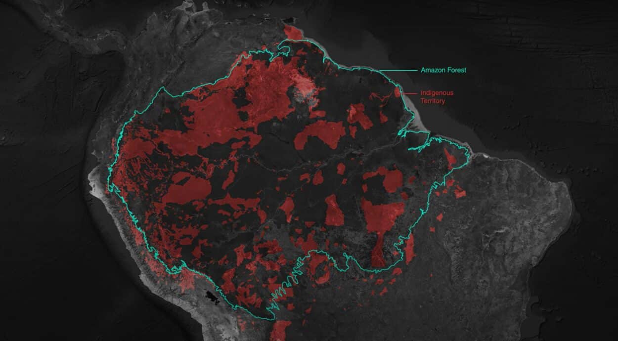
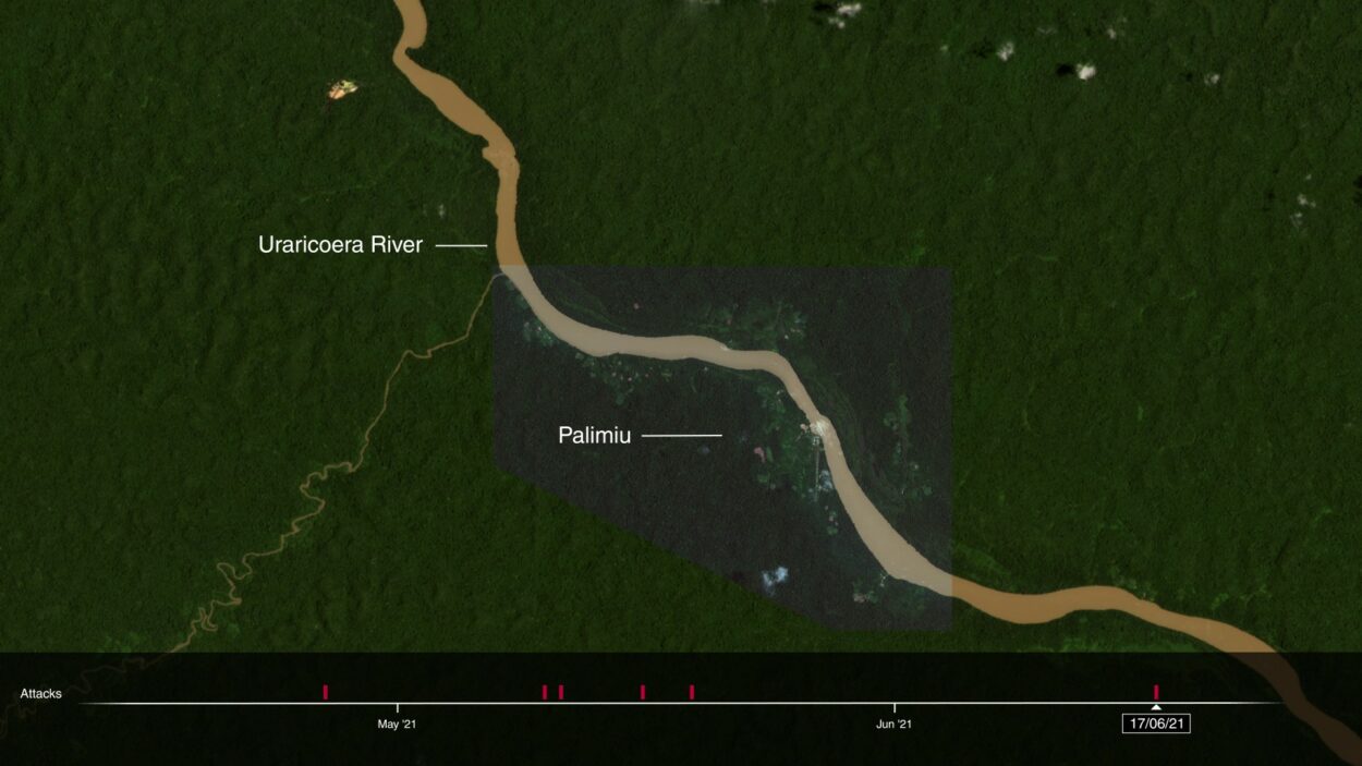
What we found through that combination of legal and spatial research – focused on tracking one river – was that the case exemplified a problem that occurs throughout indigenous lands across Brazil. We had the ability to track – year by year, sometimes month by month – the growth of deforestation on that land, using remote sensing techniques where we would map the extent of these things.
Using Remote Sensing Technology to Map Spatial Awareness
ArchiExpo e-Magazine: How does remote sensing technology work?
Omar Ferwati: Remote sensing is an open-source technique. Images are taken by satellites that include infrared, and they have different wavelengths. Using that, you can analyze the different images over time and process them to detect vegetation – to track more precisely the presence, absence and health of vegetation.
ArchiExpo e-Magazine: In the Amazon case, we’re talking about deep jungle – which isn’t what a lot of people would think of when architecture comes to mind, as it’s a term mostly associated with building design and urban planning. What was it like for you as an architect to apply some of these models, skills and techniques in a completely natural environment?
Omar Ferwati: I refer to it more as a spatial understanding in analysis, because that discipline can also be understood as a way to read spatial environments and situate things within space. It also means using techniques and skills like modeling, for example, that we learned for one reason but are repurposing for another reason, such as building a village in which shootings against these indigenous people would happen. So it’s both the skills and the sensibility that we can repurpose for this objective.
Digital Models of Villages to Match Location with Violent Occurrences
ArchiExpo e-Magazine: Did you create digital modeling of entire villages?
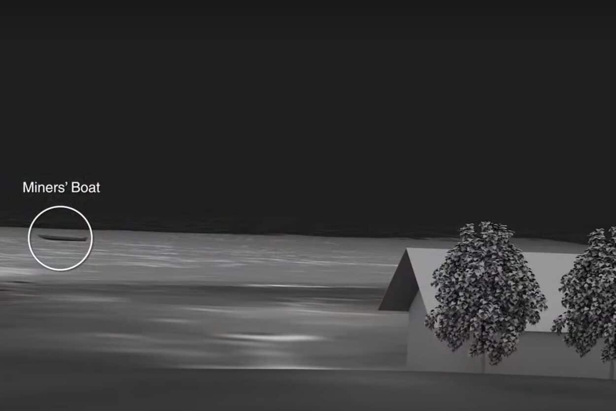
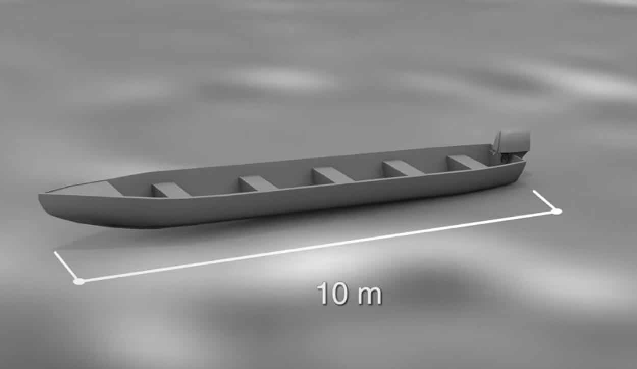
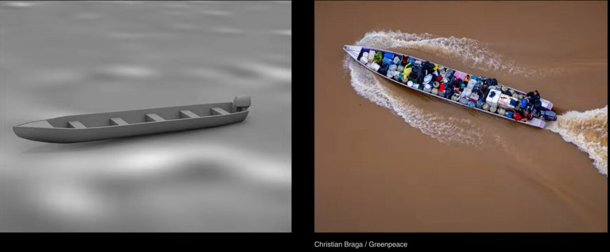
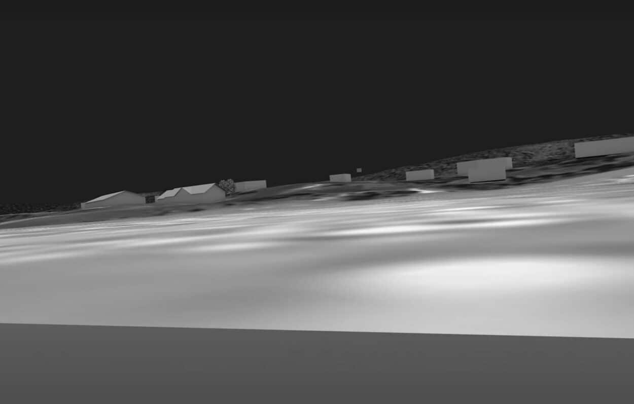
Omar Ferwati: We reconstructed one village and positioned multiple pieces of footage from different incidents in order to understand where in the village they happened, as well as their situation in a timeline of incidents, which was important for us. Our ability to locate that footage in space mattered to understand it, to verify its location, and then by doing that, you can zoom out and understand it in relation to other incidents happening around the area. For example, you can see a gold mine growing at a rapid rate less than eight kilometers away.
There was another video of gold miners passing the village. By having that model, we can match and situate it and show you just how close in proximity all those incidents were: That gold miner passing the village, the recording of a shooting on May 10 and another shooting happening on May 11. Understanding their proximity gives you a sense of the constant danger for the Yanomami living there. That’s one reason why that reconstruction was useful.
Policy on a Timeline: Bolsonaro and Crimes Against Humanity
ArchiExpo e-Magazine: When he got elected, it was pretty evident that Bolsonaro was going to open up the Amazon for these kinds of activities, but was it a challenge to accurately quantify things like deforestation or mining in such wild, remote areas?
Omar Ferwati: The challenge is that we know something to be true because we hear it from the indigenous people, whose testimony should actually be enough. They’re saying there’s been an increase in mining; we can see their lands are being stolen. What more evidence do you need to present?
What we were doing is to directly tie responsibility to the Bolsonaro administration. All we did was try to situate attacks that we knew were happening. And this is an important point: How do you explain a phenomenon that’s happening across the territory to make people understand the facts on the ground? Well, you need to connect it to things that are more abstract – like policy on a timeline – and understand its effects on people’s everyday lives.
Navigating Fake News as a Forensic Architect
ArchiExpo e-Magazine: At a time of widespread fake news plaguing the media landscape, these forensically detailed investigations have become even more critical. In terms of skills and that analytical mentality, how has your education as an architect helped you contribute to these highly cross-disciplinary projects?
Omar Ferwati: It’s hard to say exactly how my education relates to my work, but it provides a spatial sensibility and reading of the environment. So when you’re studying a piece of footage, positioning yourself and interrogating the evidence, you can see things in the background of that footage to cross-reference and situate things – understanding them in relation to one another.
As architects, we need to be conscious not only of repurposing our skills to investigate these crimes but also – for those who still practice design – to navigate and question who we work with. For example, it’s shameful that [the renowned architect] Bjarke Ingels met with Bolsonaro in 2020, after some of these atrocities had begun.
Forensic and spatial analysis provide anchors of fact and truth that allow us to challenge baseless narratives. What’s important is that we recognize the ability of civil society to challenge government narratives and eliminate the monopoly on the truth that states typically enjoy and use for their privilege.